Recommended external content
We have selected external content from YouTube for you and would like to show it to you right here. To do this, you must reveal it with one click. You can hide the external content at any time with another click.
I agree to external content from YouTube being shown to me. This may result in personal data being transmitted to third-party platforms. You can find more information in our Privacy Policy.
Motivation and Objectives
The long-term intensive data collection and research activity take place especially in sub-catchments, which serve as small hydrological study areas. The data is used for:
- the understanding of hydrological processes,
- model application and development as well as model testing with regard to sensitivities and uncertainties,
- mapping the impact of climate and land use change, land management and water management.
High-resolution measurement data and time series are a suitable basis for research projects, offering the opportunity for cooperation and networking with other universities and research institutions, with authorities and associations of environmental administration as well as local actors and residents.
The field laboratory is also subject of various student theses. Additionally, it offers space for field practices and excursions. In case studies, exercises and measurements are carried out, explaining catchment processes while making an important contribution to students' education. This is guaranteed by good process knowledge, an extensive infrastructure and the high amount of data available for the research area.
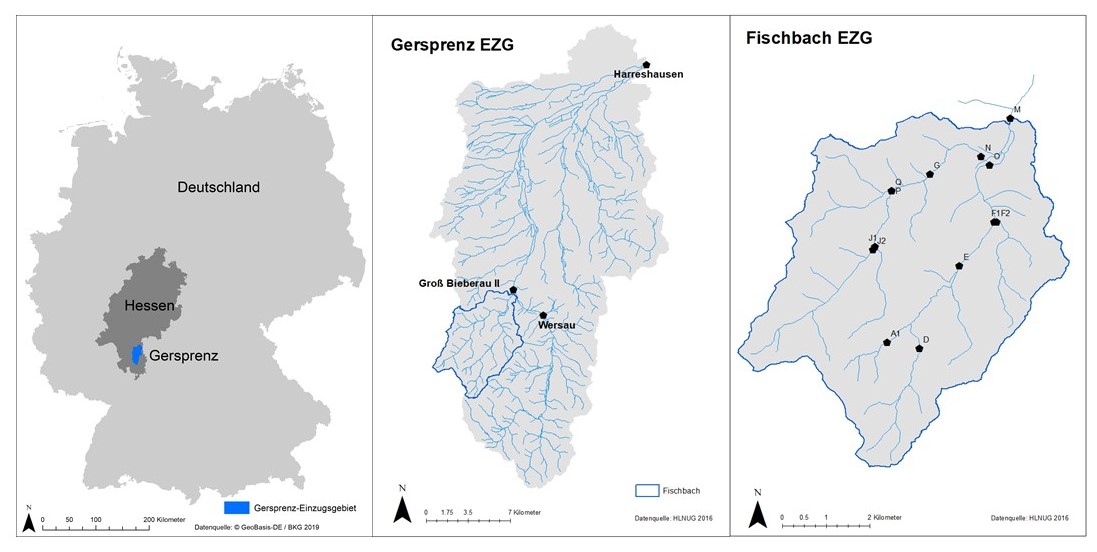
Characteristics of the Gersprenz Catchment and the Sub-Catchment of the Fischbach
The Gersprenz catchment measures 485 km² (up to the state border Hesse/Bavaria). It extends from the low mountain range area Odenwald to the lower Main river plain with altitudes ranging from about 600 m above sea level to about 100 m above sea level. 36% of the area is covered by forest, about 48% is used agriculturally and about 13% by urban areas.
The catchment is part of the Rhine river basin district. The Gersprenz sources in the crystalline Odenwald and flows into the Main river after 62 km near Stockstadt. Various larger and smaller tributaries flow into the Gersprenz. Other hydrological elements are ponds, mill canals and town/castle ditches. In addition, retention areas were created to relieve flooding.
The Fischbach catchment has a size of 35.6 km² up to the gauge Groß-Bieberau 2. The elevation in the catchment area ranges between 162 and 592 m above sea level. For flood spillway a further retention area, Herrensee / Fischbachtal, was created to protect against floods of the size HQ50.
Monitoring, Analyses and Modelling
Various sensors collect data for analyses and model studies since 2016. With the help of these data series, additional mapping and research (national data and literature values) is conducted. Furthermore, process studies are carried out, sources and pathways of input into the water body are analysed and models are developed, offering tools for scenario analyses and the development of integrative river basin management strategies.
On the one hand, the measurements comprise continuous monitoring at national gauges with documentations of important catchment characteristics, including water level, water temperature and electrical conductivity as well as partly turbidity, pH-value and oxygen content, at 5-minute resolutions. On the other hand, a weekly measurement campaign is carried out at 13 sampling points in the Fischbach. Water depth, flow velocity, water temperature, electrical conductivity and turbidity are measured. These time series allow an analysis of the spatial and temporal variability of the measured parameters.
In the framework of doctoral theses and research projects further data is collected and evaluated. Topics of interest include flooding by heavy rainfall events, the analysis of soil erosion processes and ablation forecasts, the transport and accumulation behavior of sediment and micro plastic particles, as well as the analysis of base- and low flow.
Publication list (opens in new tab)
The ihwb chair looks forward to fruitful future cooperation and thanks all those who contribute to the success!